

I've been on a little microadventure!
I've been wanting to say that for ages, I feel like I've now joined a special club! Microadventure is the latest buzz-word for, well, doing stuff. You know, like going camping overnight, or going for a long walk and a picnic, or something similar; often with minimal amounts of kit and planning, spur of the moment stuff. It's an adventure that doesn't take too long; it's a way of encouraging people to go out and do stuff, and that is a very good thing.
I hope my adventures encourage people to go out and do stuff, that would be a very good thing also! :)
Actually my adventure was more of a mini-adventure than one of the micro variety.
It was 140 miles of mountainbiking on some, at times, tough trails, with an an uncomfortable overnight camp under a little bridge. It probably doesn't sound like much fun, but it was (mostly!).
As part of my training regime for The Tour Divide (TD), in 2016, I have been looking at a few of the UK Independent-Time-Trial (ITT) challenges that are on the selfsupporteduk website. They are simply (much shorter) UK versions of the TD. Under the general guidelines of a self-supported philosophy.
------------------
This is what it says on their website:
Self-supported Philosophy
The guiding principle of self-supported riding is simply to 'do it all yourself', and the rule-set aims to provide equal and fair opportunity for all riders so times are comparable. The principle also eliminates any advantage gained by those who live near or have contacts along the route, and only allows the use of commercial premises for services, food and lodging. Respect must be paid to the honour system upon which this type of challenge sits, as ultimately it depends on each rider's integrity. The ride may be a group start or an Independent Time Trial (ITT).
Generic Rule-set
For a ride to satisfy the self-supported philosophy, it must comply with the rule-set listed below, and for the development of new routes a rule-set must be based around these key elements. Any other details related to the route or specific rules are up to the vision of the route director, normally the first person to step up and time-trial the route.
- Complete the entire route, under your own power - no drafting
- Be completely self-supported throughout the ride - absolutely no support crews, absolutely no gear sharing
- Only use commercial services that are available to all challengers - no private resupply, no private lodging
- If you have to leave the route, you must re-join it at the exactly same spot
- No caches of any kind
- No pre-arranged support, which means before you begin your ride - e.g. booking a B&B, arranging to meet a vehicle
- No travel by any motorized means during your ride - by all means do so if necessary, but understand if you do your attempt is over
----------------
You are independent, carry all of your necessary kit for the duration, follow a predetermined route from start to finish, and use only facilities that are available to anyone, as quickly as you can.
The one most local to me is The Pennine Bridleway Double. It starts at Middleton Top near Wirksworth in Derbyshire, heading roughly north for 74 miles, takes in a clockwise circumnavigation of the 47 mile Mary Towneley Loop in Yorkshire, before retracing the route back to Middleton Top; 195 miles in total, and a very tough challenge!
My plan on this trip was to reconnoitre as much of the lower section as I could over two days (out and back), in preparation for a full attempt later in the year. It would also give me an opportunity to test out some of my potential kit choices for the TD.

My bike, a Pivot Les 29er with a Kinesis IX - thru axle -rigid carbon fork, was loaded up with a range of Alpkit bikepacking luggage. (Bikepacking is simply backpacking on a bicycle!)
Within this I packed most of things I will require on the Tour Divide; not actually necessary for this trip but necessary for R&D purposes. I also had a set of Profile Designs T1+ Aerobars fitted for the same reason.
I've included a rough kit list at the end for anyone who is interested.
I set out from home at a leisurely 10.00am, it was quite a nice day, a bit of sunshine here and there, and a pleasant 17 or 18c. Perfect riding conditions. I decided on the leisurely start time because I planned to ride late in to the evening, 10-12 hours on the trail, and I knew that I had neither the fitness or endurance for a 16-18 hour day. I returned home from Nepal about 6 weeks previously and hadn't really done too much long distance riding since then.
First port of call was Mitch's house (one of my oldest friends and regular riding buddy). Mitch planned to ride with me for a few hours before turning back for home, and a night-shift at work.
We headed north out of Belper on the A6 and dropped on to the Cromford Canal towpath at Ambergate, on to High Peak Junction, then climbed up the long incline from there to Middleton Top, in no time at all. The incline was my first good challenge with the fully loaded bike, it's a long steady climb, well over a mile, that spikes to 1 in 8 for the last few hundred metres to the top. It went surprisingly well and I enjoyed it (In the perverse way that most cyclists enjoy a challenging climb!).
From here onwards I was officially recceing the route. I'm actually very familiar with the first bit, and it's an easy 17 miles ridgeline traverse on a compact, crushed limestone, surface. (It's a former railway line converted for recreational purposes; now known as The High Peak Trail). It's a beautiful trail to ride in dry conditions, however if it happens to be wet it's a horrible trail; you get covered from head to foot in a yucky limestone slime! Fortunately, on this occasion, it was very dry :)
We absolutely whizzed along and soon arrived at the Parsley Hay Cafe for a timely cup of coffee and a bacon sandwich (good old lean protein!). Somehow or other, by hook or by crook, Mitch decided that it was my turn to pay; I don't know how this happens so often, I think he works on a 3:1 ratio! It's quite expensive there these days and the coffee was average at best; I think Mitch just cherry-picks the cheaper café's for himself, the tight git doesn't like to dig too deep down into his very deep pockets! :D
After a suitably protracted break, in which we had a very interesting chat with a chap from Mercian Cycles, we continued on our way.
Mitch accompanied me along the trail all the way until Chelmorton to the top of a short descent down Calton Hill at which point he looked at his watch, took a sharp intake of breath, and decided it was time for him to return home; and then let it slip that there might be a slightly testing climb approaching. That explained his decision somewhat!
The descent took me down through a couple of fields, occupied by some bemused looking sheep (although sheep always look bemused at the best of times), across a short road section, and finally in to a rocky but thrilling plunge in to the bottom of Chee Dale which thoroughly tested the robustness of the modified locking strap on the Alpkit Koala seat pack; I'm pleased to say that it worked perfectly. The testing climb actually proved to be OK. It was a steep, but consistent, gradient out of the valley on a smooth grass covered trail. Had it been wet it would have been a bugger but in the dry it was eminently climbable with a bit of sustained effort, no doubt helped along by the big 29" wheels and the rigid fork. I hardly noticed the extra weight of the bags and kit.
After passing through Wormhill I contrived to miss the turn for Wheston and ended up in the village of Tideswell. A quick look at the map soon got me back on track and I followed a mile or so of road to pick up the official trail again. This is where the Pennine Bridleway occasionally falters a little because sometimes, it transpires, it's called The Limestone Way and later in the route it can also be The Trans-Pennine Way (more of that later)! And it's not entirely clear on the Ordnance Survey maps either. Luckily I forgot to pack my compass and so I had to resort to the odd uneducated guess at navigation through the position of the sun; it's a good job it wasn't too cloudy!
The route from Wheston, through Peak Forest, and on to Rushop Edge wasn't too taxing, the only notable climb being on a quiet country lane. From Rushop Edge the trail becomes considerably more robust, and, by proxy, a whole lot more fun.
It's classic, loose, rough & rocky, Dark Peak Mountainbiking.
No need for the map here, it's a section of trail that I have ridden many times. It begins as an undulating traverse then drops sharply in to Roych Clough, another excellent test for the security of the Koala seat pack. Of course descending in The Peaks can mean only one thing, another excellent test for my legs! I actually managed the entire climb up to South Head with only one dab of the foot, on the very steep section out of The Roych on some loose gravel. It's a challenging climb at any time so with a bike full of luggage it was particularly pleasing, of course it was definitely all down to the bike and not the rider.
From South Head to Hayfield it's pretty much a stomp on the pedals as fast as you can with just a short climb over Mount Famine.
By this point I was getting Mount Famished and decided that Hayfield would be the place for a proper meal. I called in to a small village shop and picked up a couple of cheese & onion cobs (or rolls, or baps, or whatever else you'd like to call them. In Derbyshire we call them cobs!), the bloke charged me £4.00. Four quid for two crappy cheese & onion cobs! I considered calling The Paramedics for a shot of gas & air! I was nearly hyperventilating as I stuck them in my splendid new Atom Litepak for eating later.
I rolled around the corner and spotted a sign outside a cafe that welcomed "Walkers, Cyclist's, Dog's, and Muddy Boots!" (Mind you at the prices they charged I'd have a sign outside welcoming everyone in too!)
"That's the place for me" thinks I, and promptly rested my bike in one of their conveniently located bicycle racks.
Inside I found a very chic dining area; I feared the worst, particularly when there were no prices posted against the array of choices on the menu. However that was a mere trifling distraction because I was instantly smitten by the two very beautiful young women serving behind the counter, and just like every man in such a situation I became a jibbering twat.
I ordered up a Cheeseburger & Chips and a Cafe Latte, which turned out to be one of the worlds smallest Cafe Latte's. I digress.
Eleven pounds something or other says beautiful girl No1. Cue the third sharp intake of breath that day. Hayfield was proving to be a luxury re-supply point.
Of course I remained aloof and feigned an air of indifference as I hesitantly swiped my debit card across the contactless payment thingy; all the time thinking to myself "Jesus. H. Christ someone pass me that f***ing gas & air!" This bikepacking-ITT malarky doesn't come as cheap as you'd think.
To be fair to The Roundhouse Restaurant the burger was absolutely delicious and worth every penny spent; I can highly recommend it to anyone passing through Hayfield, I'll certainly stop there again (and I'm not really that tight, honestly. Unlike Mitchell Bryan...).
Onwards and upwards; I crossed the busy main road and on to The Sett Valley Trail, why bother calling it the Pennine Bridleway when you can call it something completely different just for a change. Fortunately it was very easy navigation and the PBW was soon back to its proper name. The climb up Lantern Pike is another good one, starting on the familiar cobble strewn trail but relenting higher up to a nice compact surface for the "summit" push, and then a pleasant glide on country lanes in to Charlesworth. It's at this point the route becomes convoluted again and I ended up trying to route find in the lost village of Broadbottom, fortunately Ordnance Survey have managed to cunningly disguise a section of footpath (off limits to cyclists) as, you've guessed it, bridleway! Passing through a small hamlet I was confronted by a rather stocky, not-to-be-messed-with, bald headed man, who proceeded to chastise me for straying off-piste. I learnt long ago not to antagonise churlish gentlemen who are bigger than me and so I was politeness personified. It turned out that he was very familiar with the Ordnance Survey's error and because I had been such a nice man he allowed me to continue on down the track to pick up the correct route rather than making me detour backwards several miles. I told him he was a very nice man, bode him a splendid evening and went speeding off down the hill before he could change his mind.
That was the start of my troubles. (I'm going to have to return to the area once more just to clarify the route properly).
In the area around Hadfield, Hollingworth, and Tintwistle I ended up going around in circles until eventually finding another of those cunningly disguised mapping errors, notwithstanding a bit of telephone navigational help from Mitch too. I ended up on an interim walkers route apparently, and, more by luck than judgement, got back on-route at the village of Arnfield after a couple of hours of being thoroughly pissed-off. Two good climbs and a descent and I found myself at The Swineshaw Reservoirs, a nice quiet spot for a nights bivvying.
I got myself surreptitiously ensconced under a little bridge out of harms way and settled down to enjoy my crappy and expensive cheese & onion cob. Imagine my delight when I bite in to it enthusiastically only to discover a lump of bloody tomato. (Anyone who knows me even a little bit will understand that statement. I really, really, don't like fresh tomato! Why would anyone want to eat a fruit that thinks it's a vegetable? You wouldn't put tomato in a nice fruit salad now would you? Yuck).
Said piece of tomato was unceremoniously ejected in to reservoir for the fish to eat (I'll bet they wouldn't eat it either).
I enjoyed a fitful nights sleep, on the flagstone surface of the spillway, under the bridge, and arose fairly knackered at about 4.30am for my ride back home.
It all went swimmingly until I arrived in the now legendary Hollingworth/Hadfield/Tintwistle Twilight Zone, but I managed to muddle a way through and before very long at all I was once again climbing out of Roych Clough and onwards to Rushop Edge.
Hunger was beginning to get the better of me, and knowing that there was little in the way of services for a good twenty miles, and because my bum was starting to get a bit saddle sore, I decided that I would follow the road down Winnats Pass in to Castleton, get a bite to eat at Outside in Hathersage, and take the easy spin home on the road.
I had myself a man-sized English Breakfast in the cafe at Outside, I deserved it after all, and whilst I was there purchased myself a nice shiny copy of the Harvey - Pennine Bridleway South route map. An excellent purchase. The route is really well marked and there's plenty of additional information on it too, including the full "Mary Towneley Loop" section. If you are fancying a ride on the PBW buy this map, not the OS version.
The ride home on proper roads was a breeze, although a little boring. It's amazing how easy it feels to ride on a tarmacadam surface after the thrill of riding trails, however it was a means to an end and my bum was sore! The forty or so miles flew by and in no time whatsoever I was back in the comfort of home with the kettle on :)
Kit list:
On the handlebars is an Airlok Dual 20l dry bag containing a Hunka bivvy bag, Rab Neutrino 200 sleeping bag, Thermarest Prolite 3/4 sleep mat, and an empty Platypus 2l Softbottle.
-------------------
On the top-tube are small and medium Fuel Pods:
The small one contains a spare innertube and trail tools.
The medium sized one contains Torq bars/gels, a small cable lock, iPhone, and a 6000mAh Powerbank for charging my iPhone and GPS.
--------------------
The custom fitted Stingray frame bag:
Document pocket - Platypus 1l Softbottle, Sawyer Mini Water Filter.
Main compartment (Surgeon pocket) - Batteries, First Aid Kit, Maps, Sudocrem, Toiletries, Spare parts, Jelly Babies.
--------------------
On the back sits a Koala seat pack with:
4l Airlok Dry bag - Spare cycling kit - Bib Short, Alpkit Kepler Long Sleeve Merino Tee-Shirt, Merino Wool Socks. Sealskinz Socks.
8l Airlok Dry bag - Nightwear - Pair of Shorts, Alpkit Kepler Merino Boxer Shorts, Alpkit Kepler Merino Short Sleeved Tee-Shirt, Merino Wool Socks, Rab Microlight Vest (Gilet), Microfibre Travel Towel.
--------------------
Osprey Talon 8 Lumbar Pack:
2 x 600mls Camelbak Podium Bottles.
Gore Bike Wear Alp-X 2.0 Waterproof Trousers
Rab Spark Waterproof Jacket
Gore Bike Wear SO Knee Warmers
Alpkit Atom Litepak (for extra food)
You are independent, carry all of your necessary kit for the duration, follow a predetermined route from start to finish, and use only facilities that are available to anyone, as quickly as you can.
The one most local to me is The Pennine Bridleway Double. It starts at Middleton Top near Wirksworth in Derbyshire, heading roughly north for 74 miles, takes in a clockwise circumnavigation of the 47 mile Mary Towneley Loop in Yorkshire, before retracing the route back to Middleton Top; 195 miles in total, and a very tough challenge!
My plan on this trip was to reconnoitre as much of the lower section as I could over two days (out and back), in preparation for a full attempt later in the year. It would also give me an opportunity to test out some of my potential kit choices for the TD.

My bike, a Pivot Les 29er with a Kinesis IX - thru axle -rigid carbon fork, was loaded up with a range of Alpkit bikepacking luggage. (Bikepacking is simply backpacking on a bicycle!)
Within this I packed most of things I will require on the Tour Divide; not actually necessary for this trip but necessary for R&D purposes. I also had a set of Profile Designs T1+ Aerobars fitted for the same reason.
I've included a rough kit list at the end for anyone who is interested.
I set out from home at a leisurely 10.00am, it was quite a nice day, a bit of sunshine here and there, and a pleasant 17 or 18c. Perfect riding conditions. I decided on the leisurely start time because I planned to ride late in to the evening, 10-12 hours on the trail, and I knew that I had neither the fitness or endurance for a 16-18 hour day. I returned home from Nepal about 6 weeks previously and hadn't really done too much long distance riding since then.
First port of call was Mitch's house (one of my oldest friends and regular riding buddy). Mitch planned to ride with me for a few hours before turning back for home, and a night-shift at work.
We headed north out of Belper on the A6 and dropped on to the Cromford Canal towpath at Ambergate, on to High Peak Junction, then climbed up the long incline from there to Middleton Top, in no time at all. The incline was my first good challenge with the fully loaded bike, it's a long steady climb, well over a mile, that spikes to 1 in 8 for the last few hundred metres to the top. It went surprisingly well and I enjoyed it (In the perverse way that most cyclists enjoy a challenging climb!).
 |
| Middleton Top. The official start of The Pennine Bridleway. |
From here onwards I was officially recceing the route. I'm actually very familiar with the first bit, and it's an easy 17 miles ridgeline traverse on a compact, crushed limestone, surface. (It's a former railway line converted for recreational purposes; now known as The High Peak Trail). It's a beautiful trail to ride in dry conditions, however if it happens to be wet it's a horrible trail; you get covered from head to foot in a yucky limestone slime! Fortunately, on this occasion, it was very dry :)
We absolutely whizzed along and soon arrived at the Parsley Hay Cafe for a timely cup of coffee and a bacon sandwich (good old lean protein!). Somehow or other, by hook or by crook, Mitch decided that it was my turn to pay; I don't know how this happens so often, I think he works on a 3:1 ratio! It's quite expensive there these days and the coffee was average at best; I think Mitch just cherry-picks the cheaper café's for himself, the tight git doesn't like to dig too deep down into his very deep pockets! :D
 |
| Whizzing along The High Peak Trail for coffee and bacon! The aerobars proved really useful along this section. |
 |
| It's a very pleasant cruise along the High Peak Trail when the weather is dry. |
After a suitably protracted break, in which we had a very interesting chat with a chap from Mercian Cycles, we continued on our way.
Mitch accompanied me along the trail all the way until Chelmorton to the top of a short descent down Calton Hill at which point he looked at his watch, took a sharp intake of breath, and decided it was time for him to return home; and then let it slip that there might be a slightly testing climb approaching. That explained his decision somewhat!
 |
| The top of Calton Hill on the way to Chee Dale. The point at which Mitch took his leave. |
 |
| The start of my solo efforts at the top of Calton Hill near Chelmorton. |
The descent took me down through a couple of fields, occupied by some bemused looking sheep (although sheep always look bemused at the best of times), across a short road section, and finally in to a rocky but thrilling plunge in to the bottom of Chee Dale which thoroughly tested the robustness of the modified locking strap on the Alpkit Koala seat pack; I'm pleased to say that it worked perfectly. The testing climb actually proved to be OK. It was a steep, but consistent, gradient out of the valley on a smooth grass covered trail. Had it been wet it would have been a bugger but in the dry it was eminently climbable with a bit of sustained effort, no doubt helped along by the big 29" wheels and the rigid fork. I hardly noticed the extra weight of the bags and kit.
 |
| Half way up the climb out of Chee Dale. |
After passing through Wormhill I contrived to miss the turn for Wheston and ended up in the village of Tideswell. A quick look at the map soon got me back on track and I followed a mile or so of road to pick up the official trail again. This is where the Pennine Bridleway occasionally falters a little because sometimes, it transpires, it's called The Limestone Way and later in the route it can also be The Trans-Pennine Way (more of that later)! And it's not entirely clear on the Ordnance Survey maps either. Luckily I forgot to pack my compass and so I had to resort to the odd uneducated guess at navigation through the position of the sun; it's a good job it wasn't too cloudy!
The route from Wheston, through Peak Forest, and on to Rushop Edge wasn't too taxing, the only notable climb being on a quiet country lane. From Rushop Edge the trail becomes considerably more robust, and, by proxy, a whole lot more fun.
It's classic, loose, rough & rocky, Dark Peak Mountainbiking.
No need for the map here, it's a section of trail that I have ridden many times. It begins as an undulating traverse then drops sharply in to Roych Clough, another excellent test for the security of the Koala seat pack. Of course descending in The Peaks can mean only one thing, another excellent test for my legs! I actually managed the entire climb up to South Head with only one dab of the foot, on the very steep section out of The Roych on some loose gravel. It's a challenging climb at any time so with a bike full of luggage it was particularly pleasing, of course it was definitely all down to the bike and not the rider.
From South Head to Hayfield it's pretty much a stomp on the pedals as fast as you can with just a short climb over Mount Famine.
By this point I was getting Mount Famished and decided that Hayfield would be the place for a proper meal. I called in to a small village shop and picked up a couple of cheese & onion cobs (or rolls, or baps, or whatever else you'd like to call them. In Derbyshire we call them cobs!), the bloke charged me £4.00. Four quid for two crappy cheese & onion cobs! I considered calling The Paramedics for a shot of gas & air! I was nearly hyperventilating as I stuck them in my splendid new Atom Litepak for eating later.
I rolled around the corner and spotted a sign outside a cafe that welcomed "Walkers, Cyclist's, Dog's, and Muddy Boots!" (Mind you at the prices they charged I'd have a sign outside welcoming everyone in too!)
"That's the place for me" thinks I, and promptly rested my bike in one of their conveniently located bicycle racks.
Inside I found a very chic dining area; I feared the worst, particularly when there were no prices posted against the array of choices on the menu. However that was a mere trifling distraction because I was instantly smitten by the two very beautiful young women serving behind the counter, and just like every man in such a situation I became a jibbering twat.
I ordered up a Cheeseburger & Chips and a Cafe Latte, which turned out to be one of the worlds smallest Cafe Latte's. I digress.
Eleven pounds something or other says beautiful girl No1. Cue the third sharp intake of breath that day. Hayfield was proving to be a luxury re-supply point.
Of course I remained aloof and feigned an air of indifference as I hesitantly swiped my debit card across the contactless payment thingy; all the time thinking to myself "Jesus. H. Christ someone pass me that f***ing gas & air!" This bikepacking-ITT malarky doesn't come as cheap as you'd think.
To be fair to The Roundhouse Restaurant the burger was absolutely delicious and worth every penny spent; I can highly recommend it to anyone passing through Hayfield, I'll certainly stop there again (and I'm not really that tight, honestly. Unlike Mitchell Bryan...).
 |
| The climb up Lantern Pike starts fairly hard but eases to compact gravel about half way up. |
Onwards and upwards; I crossed the busy main road and on to The Sett Valley Trail, why bother calling it the Pennine Bridleway when you can call it something completely different just for a change. Fortunately it was very easy navigation and the PBW was soon back to its proper name. The climb up Lantern Pike is another good one, starting on the familiar cobble strewn trail but relenting higher up to a nice compact surface for the "summit" push, and then a pleasant glide on country lanes in to Charlesworth. It's at this point the route becomes convoluted again and I ended up trying to route find in the lost village of Broadbottom, fortunately Ordnance Survey have managed to cunningly disguise a section of footpath (off limits to cyclists) as, you've guessed it, bridleway! Passing through a small hamlet I was confronted by a rather stocky, not-to-be-messed-with, bald headed man, who proceeded to chastise me for straying off-piste. I learnt long ago not to antagonise churlish gentlemen who are bigger than me and so I was politeness personified. It turned out that he was very familiar with the Ordnance Survey's error and because I had been such a nice man he allowed me to continue on down the track to pick up the correct route rather than making me detour backwards several miles. I told him he was a very nice man, bode him a splendid evening and went speeding off down the hill before he could change his mind.
That was the start of my troubles. (I'm going to have to return to the area once more just to clarify the route properly).
In the area around Hadfield, Hollingworth, and Tintwistle I ended up going around in circles until eventually finding another of those cunningly disguised mapping errors, notwithstanding a bit of telephone navigational help from Mitch too. I ended up on an interim walkers route apparently, and, more by luck than judgement, got back on-route at the village of Arnfield after a couple of hours of being thoroughly pissed-off. Two good climbs and a descent and I found myself at The Swineshaw Reservoirs, a nice quiet spot for a nights bivvying.
 |
| The sun setting over Swinesshaw Reservoirs, nearly time for bed. |
I got myself surreptitiously ensconced under a little bridge out of harms way and settled down to enjoy my crappy and expensive cheese & onion cob. Imagine my delight when I bite in to it enthusiastically only to discover a lump of bloody tomato. (Anyone who knows me even a little bit will understand that statement. I really, really, don't like fresh tomato! Why would anyone want to eat a fruit that thinks it's a vegetable? You wouldn't put tomato in a nice fruit salad now would you? Yuck).
Said piece of tomato was unceremoniously ejected in to reservoir for the fish to eat (I'll bet they wouldn't eat it either).
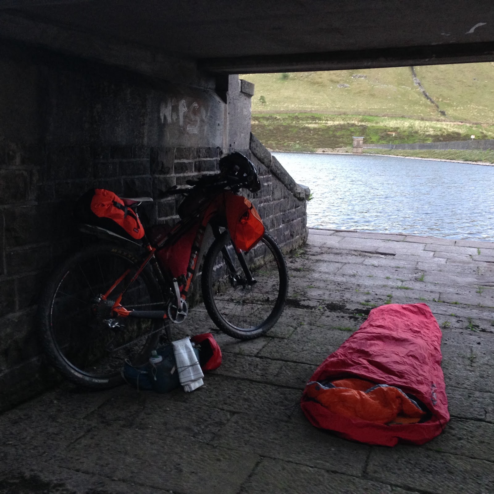 | ||
My impromptu camp for the night.
|

I enjoyed a fitful nights sleep, on the flagstone surface of the spillway, under the bridge, and arose fairly knackered at about 4.30am for my ride back home.
It all went swimmingly until I arrived in the now legendary Hollingworth/Hadfield/Tintwistle Twilight Zone, but I managed to muddle a way through and before very long at all I was once again climbing out of Roych Clough and onwards to Rushop Edge.
Hunger was beginning to get the better of me, and knowing that there was little in the way of services for a good twenty miles, and because my bum was starting to get a bit saddle sore, I decided that I would follow the road down Winnats Pass in to Castleton, get a bite to eat at Outside in Hathersage, and take the easy spin home on the road.
I had myself a man-sized English Breakfast in the cafe at Outside, I deserved it after all, and whilst I was there purchased myself a nice shiny copy of the Harvey - Pennine Bridleway South route map. An excellent purchase. The route is really well marked and there's plenty of additional information on it too, including the full "Mary Towneley Loop" section. If you are fancying a ride on the PBW buy this map, not the OS version.
The ride home on proper roads was a breeze, although a little boring. It's amazing how easy it feels to ride on a tarmacadam surface after the thrill of riding trails, however it was a means to an end and my bum was sore! The forty or so miles flew by and in no time whatsoever I was back in the comfort of home with the kettle on :)
 |
| Random scenic shot on my return journey towards home. |
Kit list:
On the handlebars is an Airlok Dual 20l dry bag containing a Hunka bivvy bag, Rab Neutrino 200 sleeping bag, Thermarest Prolite 3/4 sleep mat, and an empty Platypus 2l Softbottle.
-------------------
On the top-tube are small and medium Fuel Pods:
The small one contains a spare innertube and trail tools.
The medium sized one contains Torq bars/gels, a small cable lock, iPhone, and a 6000mAh Powerbank for charging my iPhone and GPS.
--------------------
The custom fitted Stingray frame bag:
Document pocket - Platypus 1l Softbottle, Sawyer Mini Water Filter.
Main compartment (Surgeon pocket) - Batteries, First Aid Kit, Maps, Sudocrem, Toiletries, Spare parts, Jelly Babies.
--------------------
On the back sits a Koala seat pack with:
4l Airlok Dry bag - Spare cycling kit - Bib Short, Alpkit Kepler Long Sleeve Merino Tee-Shirt, Merino Wool Socks. Sealskinz Socks.
8l Airlok Dry bag - Nightwear - Pair of Shorts, Alpkit Kepler Merino Boxer Shorts, Alpkit Kepler Merino Short Sleeved Tee-Shirt, Merino Wool Socks, Rab Microlight Vest (Gilet), Microfibre Travel Towel.
--------------------
Osprey Talon 8 Lumbar Pack:
2 x 600mls Camelbak Podium Bottles.
Gore Bike Wear Alp-X 2.0 Waterproof Trousers
Rab Spark Waterproof Jacket
Gore Bike Wear SO Knee Warmers
Alpkit Atom Litepak (for extra food)


No comments:
Post a Comment